Significant Ecological Areas in the Santa Clarita Valley
Note: The County of Los Angeles Department of Regional Planning has updated the Significant Ecological Area (SEA) portion of the General Plan, reducing significantly the number of Significant Ecological Areas, both in the county and in the Santa Clarita Valley. We will soon update this list, which is from before the March 2015 Update.
There are 62 Significant Ecological Areas (SEAs) identified in Los Angeles County. Five of these are located in the Santa Clarita Valley:
Interactive Map:

What is an SEA?
The concept of a ‘significant ecological area’ is – at least in Southern California – unique to Los Angeles County. Surrounding counties have not explicitly identified such areas. Los Angeles County developed the concept in the 1970’s in conjunction with adopting the original General Plan for the County, and SEAs are defined and delineated in conjunction with the Land Use and Open Space Elements of the County General Plan. Language in the Santa Clarita Areawide General Plan regarding SEAs echos that of the overall County Plan, with focus on the five SCV SEAs, as does the City of Santa Clarita General Plan’s Land Use and Open Space Elements.
An area qualifies for recognition as an SEA if it possesses one or more of the following features, or classes:
- Is the habitat of rare, endangered, or threatened plant or animal species.
- Represents biotic communities, vegetative associations, or habitat of plant or animal species that are either one-of-a-kind, or are restricted in distribution on a regional basis.
- Represents biotic communities, vegetative associations, or habitat of plant or animal species that are either one-of-a-kind, or are restricted in distribution in Los Angeles County.
- Is habitat that at some point in the life cycle of a species or group of species, serves as a concentrated breeding, feeding, resting, or migrating grounds, and is limited in availability
- Represents biotic resources that are of scientific interest because they are either an extreme in physical/geographical limitations, or they represent an unusual variation in a population or community.
- Is an area important as game species habitat or as fisheries.
- Is an area that would provide for the preservation of relatively undisturbed examples of the natural biotic communities in Los Angeles County.
- Is a special area, worthy of inclusion, but one which does not fit any of the other seven criteria.
Lyon Canyon (SEA #63)

This is the smallest SEA in the Santa Clarita Area, and is located southwest of the Sunset Pointe housing tract west of I-5. It typifies a oak grove and chapperal community, and thus qualifies in Class 7. A proposed expansion of Stevenson Ranch would decimate this SEA to the point where it would no longer be viable.
San Francisquito Canyon (SEA #19)

This SEA was established to preserve habitat associated with the unarmored stickleback fish, an endangered species. Originally at 1,330 acres, the SEA has been reduced to less than 1,220 acres and is characterized as ‘severely degraded’. A 1,220 acre buffer originally mapped around this SEA has been virtually eliminated by new residential and commercial developments in the canyon.
Santa Clara River (SEA #23)

Originally mapped out at 5,690 acres, this SEA is functionally covering 5,410 acres and is also listed as ‘severely degraded’. It provides stickleback habitat, and qualifies as an SEA in Classes 1, 2, 3, 4 and 7. The SEA represents the last major unchanneled river in Los Angeles County.
Santa Susan Mountains (SEA #20)

Encompassing about 18,380 acres, this is the largest SEA in the vicinity of the SCV, and is listed as ‘moderately degraded’. It qualifies as an SEA under Classes 1, 2, 3, 4, 5, 6 and 7. The SEA includes the Santa Clarita Woodlands State Park, but is also threatened by both the expansion of the Sunshine Canyon landfill and the proposed Towsley Canyon landfill.
You can take many hikes through portions of the Woodlands. At the southeast end, there are Rice and East Canyons, and a pair of moderate hikes, one on a dirt road, the other a sometimes narrow walking trail. Streams and small waterfalls can be found on both hikes. These two canyons are unique in that the ridges at their crest are typically bathed in fog spilling over from the San Fernando Valley.
Just off The Old Road at Calgrove are other interesting hikes in Towsley and Wiley Canyons (in Ed Davis Park). Since this is probably the most publicly accessable of the SEAs, with bicycles allowed on all but Rice Canyon, it is also subject to the most damage by careless visitors, and the bikes often do damage to the trails. Besides, you will miss many of the small plants and flowers that flourish along these trails rushing through on two wheels.
All four hikes give outstanding views, either inside the SEA, or out towards the Santa Clarita Valley. They traverse a variety of microclimates with drastically changing flora, with wildflowers at their peak in the late spring.
Valley Oak Savannah (SEA #64)

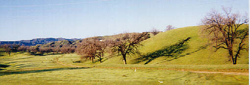
This 300+ acre area west of I-5, between McBean Parkway and Valencia Boulevard, is the southernmost large-scale extent of the Valley Oak in Los Angeles County. It therefore qualifies under Classes 3 and 5. Various plan revisions and unofficial boundary changes have gradually shrunk the size of this SEA, and the proposed Westridge commercial/residential development effects profound changes on this SEA, probably beyond recovery.

You must be logged in to post a comment.